
Russian authorities have cancelled a tsunami alert for the Kamchatka Peninsula following a 7.0 magnitude earthquake near the Kuril Islands, which struck on August 3. The event coincided with the first confirmed eruption of the Krasheninnikov Volcano in over 600 years, adding to concerns in a region already shaken by intense seismic activity.
Although officials had initially cautioned residents to stay clear of the coast, they later confirmed that only minor wave activity was expected. The Pacific Tsunami Warning System and the United States Geological Survey both measured the tremor at magnitude 7.0, and neither agency issued a tsunami warning.
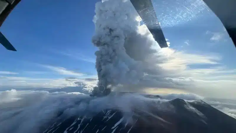
Volcano Erupts Possibly Due to Tremors
In a separate but possibly related development, the Krasheninnikov Volcano in Kamchatka erupted overnight, marking its first confirmed activity in over 600 years.
Experts believe both the earthquake and the eruption could be linked to the major seismic event that struck Russia’s Far East last week. That earlier quake had prompted tsunami warnings as far as Chile and French Polynesia and was followed by an eruption of Kamchatka’s most active volcano, Klyuchevskoy.
The Kuril Islands chain extends southward from the Kamchatka Peninsula, an area geologists had recently identified as vulnerable to further aftershocks. On July 30, Russian researchers warned that more strong tremors could occur in the coming weeks.
«This is the first historically verified eruption of the Krasheninnikov Volcano in 600 years,» said Olga Girina, head of the Kamchatka Volcanic Eruption Response Team.
According to Girina, the last known lava flow from Krasheninnikov occurred within four decades of 1463, with no recorded activity since then.
Following the eruption, the Kamchatka division of the emergency services ministry reported an ash cloud reaching up to 6,000 metres (approximately 3.7 miles) in height. The volcano itself stands at 1,856 metres above sea level.
Ash plume is moving eastward across the Pacific Ocean, and officials confirmed that no populated areas are located along its trajectory.
The eruption has been classified under the orange aviation alert level, indicating an elevated risk for air traffic due to volcanic ash.